
Timber Fire becomes one of California's largest 2026 wildfires as it burns through Big Sur backcountry
Nearly three weeks after igniting in the Los Padres National Forest, the fire has forced repeated evacuation orders and shut down stretches of Highway 1.

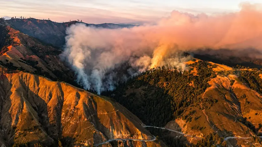
Smoke rising over the hills near Big Sur | Cal Fire
The Timber Fire, burning in rugged backcountry near Big Sur in the Los Padres National Forest, has grown into one of California's largest wildfires of the year, with fire crews still working to gain a firm hold on its perimeter nearly three weeks after it first ignited.
The fire started on the night of August 8 in steep, hard-to-reach terrain in Monterey County. By late August it had burned more than 19,000 acres, with containment sitting at roughly one-fifth of the perimeter, according to figures from the multi-agency incident command overseeing the response.
You might be interested in
More than 660 structures have been listed as threatened at various points in the fire's spread, and evacuation orders and warnings have been issued and expanded repeatedly for communities in the surrounding canyons. Stretches of the coastal Highway 1 have also been closed intermittently as crews worked to keep the road corridor clear for fire equipment and to protect it from falling debris.
At the height of the response, several hundred personnel were assigned to the fire, backed by dozens of engines, hand crews, bulldozers, water tenders and helicopters making repeated water and retardant drops on the steepest slopes, where the terrain has made direct ground attack difficult in places.
The cause of the fire remains under investigation. It is one of several large wildfires that have burned across California this year, a season fire officials describe as active but not unprecedented, shaped by a dry summer and the dense brush that has built up in parts of the Central Coast's national forest land after recent wetter winters.
Local officials have urged residents in the fire's path to monitor evacuation alerts closely, noting that shifting winds in the area's steep canyons can change containment lines quickly even after progress has been made on a given day.